
This is an interesting, but remote, corner of Newberry National Volcanic Monument. A one-mile loop trail takes you through a lava flow, and reveals something unusual: “casts” of ancient trees, formed when lava swept through the ancient forest.
My Visit

I didn’t know much about the Lava Cast Forest when I decided to drive out to it. It’s somewhat inconvenient to access, and by the time I arrived, I was wondering if I had made a bad choice.
Then, I started walking the loop trail, and I really started to wonder if I had wasted my time. From the parking lot, the trail immediately heads into a basalt lava flow, formed during a volcanic eruption 7,000 years ago. That’s interesting, sure, but there’s no shortage of volcanic rock in central Oregon — you don’t need to make a long detour to see it.
It also wasn’t helping my attitude to discover that everything along the trail was marked with numbers. That would have been great, if I had the pamphlet that went with it. Instead, I took pictures of the markers, so I could look up the information later. For example, marker #2:
Hot molten lava flowed through the pine forest, surrounding or covering most existing life in its path. Present plants, rooted in wind-deposited ash, demonstrate nature’s ability to revegetate the lava flow area.

I wasn’t seeing anything that looked like a 7,000 year old tree — although the trail did have some pretty-old looking tree trunks.

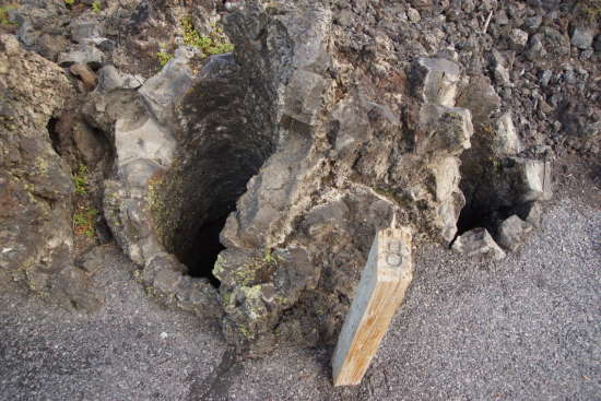
I also spotted this unusual “mouth” in one tree trunk. Interesting, but probably not what I was supposed to be seeing.
It took a while, but finally…

… I started running into the actual lava casts. It’s still nothing thrilling, but it is interesting to think that, 7,000 years ago, a tree stood here, minding its own business, when a wall of lava swept over the land, encasing the tree and creating a mold of the trunk that would last thousands of years longer than the tree could have ever hoped to have lived.
According to the guide, #6 says:
Tree molds were formed as lava spilled through the pine forest, flowing against the upstream side of the tree trunks. Lava Cast Forest derives its name from the concentration of these features. A more accurate explanation, however, defines a cast as having filled a mold, while a mold is formed around an object such as a tree.

Once you finally see the first one, you’ll start seeing them everywhere.

These ‘casts’ look a lot like an old, cement-walled chimney.
Marker #8:
Three trees came from this single stump. The holes join at the base.

This is one of the prettier spots along the trail, near the end, where you get a sweeping view of the surrounding landscape.
Marker #9:
Fissures containing a series of vents extend almost seven miles in a northwesterly direction. This line of weakness in the earth’s crust originates at East Lake in the caldera of Newberry Volcano. At this trail stop, Newberry Volcano occupies the entire skyline. Fissures should not be confused with cooling cracks clearly visible from here.

Marker #10:
When lava surged through the stands of pine, some trees were pushed over by its force. Trees that were snapped off were carried away. Others remained, anchored by their roots. Horizontal molds show this feature.
Sure enough, that’s the mold of a horizontal tree — a tiny tunnel of sorts.

Aside from the lava casts, I enjoyed photographing the old stumps and moss-covered logs along the trail.

And, the trail itself was fun — although I’m not certain it’s worth the long drive to get here.
If you’d like to see all of the descriptions that go with the trail markers, they are transcribed on this Waymarking.com page.
The Bottom Line
This trail feels like some place you’d be forced to go on a school field trip — not so much a place you’d go voluntarily, to enjoy a hike or some scenery. It’s interesting to see the lava casts, and the hike is nice enough. But, the long drive out and back make the Lava Cast Forest Trail less appealing. I’d suggest making the drive out here, only after you’ve checked out the more interesting destinations in the Bend area.
Location
The Lava Cast Forest is located south of Bend, north of Paulina Lake, and east of US 97. Unfortunately, you can’t drive directly north from the Paulina Lake area — you can only access the Lava Cast Forest via a 9-mile forest road that begins at exit 153 off US 97.
The road to the Lava Cast Forest is marked as “unimproved” on park maps, but it’s in good condition and easy to drive.
Drivelapse Video
Check out this time-lapse, dash-cam video of the drive out to the Lava Cast Forest, then on to Tumalo Falls near Bend:


No comments