
Garfield Peak is Crater Lake’s most convenient trail. Thanks to its location on the south rim, near the area that’s kept open year-round, you should be able to access this trail at almost any time, assuming the snow isn’t too deep.
My Visit

When I arrived at Crater Lake (in late September), I was somewhat frustrated to find out that a snowstorm the previous night had closed the entire loop road. Because I was entering the park from the south, on Route 62, I was able to get up to Rim Village — but I couldn’t go either direction around the lake. I started to wonder if I’d have any hiking options at all. Then, I discovered Garfield Peak.
That’s Garfield Peak in the photo above, right behind Crater Lake Lodge. At sunset, the mountain is beautifully lit. Earlier in the day…

… it looked much more ominous. It was still flurrying, on and off, and low-hanging clouds occasionally swept over the peak. I wasn’t sure what I would be able to see at the top, but I didn’t have many other options for hiking, so I gave it a try.
As you can see, the trail was well packed, and even somewhat slushy, at this point. Of course, I was still down by the lodge, in an area where non-hikers would be walking. I splashed through the slop…

… until I was on the real trail, which backs away from the rim in places. It was a winter wonderland, and I hadn’t even gotten to the most magical, snow-plastered parts.
I’d guess that, perhaps, a dozen people had hiked the trail before me, so it was easy to follow, and the snow was packed enough in most places to make walking easy. It would be much more difficult if you were the first person to hike the trail, immediately after a snowfall.

Along the way to the top, the trail has a few wonderful encounters with the rim of the lake. Even if you didn’t hike all the way to the top of Garfield Peak, this viewpoint would make a rewarding destination.

You’ll have a nice view of Wizard Island from here. If the West Rim Road doesn’t open up, this will be about as close as you can get to it.

The trail comes close to the rim at times, and then ducks behind those rocky outcroppings.

Although the view in these areas isn’t excellent (you can’t see the lake), it’s still a beautiful spot.

A bit further on, there’s another viewpoint…

… where you’ll have a good view of the east rim…

… and a nice vantage point looking west, as well.
The weather at Crater Lake is remarkable. If you had been on the west rim at this point, you’d have been in a snowy fog, unable to see anything. However, I was enjoying sunshine and blue skies.

The trail passes this stone structure, which appears to be a water tank, perhaps?

Look to the south, and you’ll have a good view of the twisty highway that connects with the rim.

With just a few inches of snow on the ground, this trail is relatively safe to hike. If there was a foot or two, it might be much more dangerous, since there’s a pretty steep drop on the side.

Once again, the trail turned towards the rim, but this time, there was no wall — just some trees, which had been brutally assaulted by the previous night’s storm.

This is what it looks like in late September — barely into fall, with winter still months away. Just imagine what these poor trees endure during the coldest, snowiest months of the year.

I spent a lot of time in this area, taking pictures of the snow-flocked trees. Suddenly, I wasn’t quite as disappointed about the snowstorm, and the rim road being closed. I wasn’t expecting this kind of a hike on this trip — this was better.

Along the way, you’ll have an excellent angle for viewing Phantom Ship — a tiny, jagged island on the east side of the lake. There aren’t many places where you get a good, unobstructed view of this Crater Lake feature, so be sure to take a few pictures.
Click on the image for a larger version.
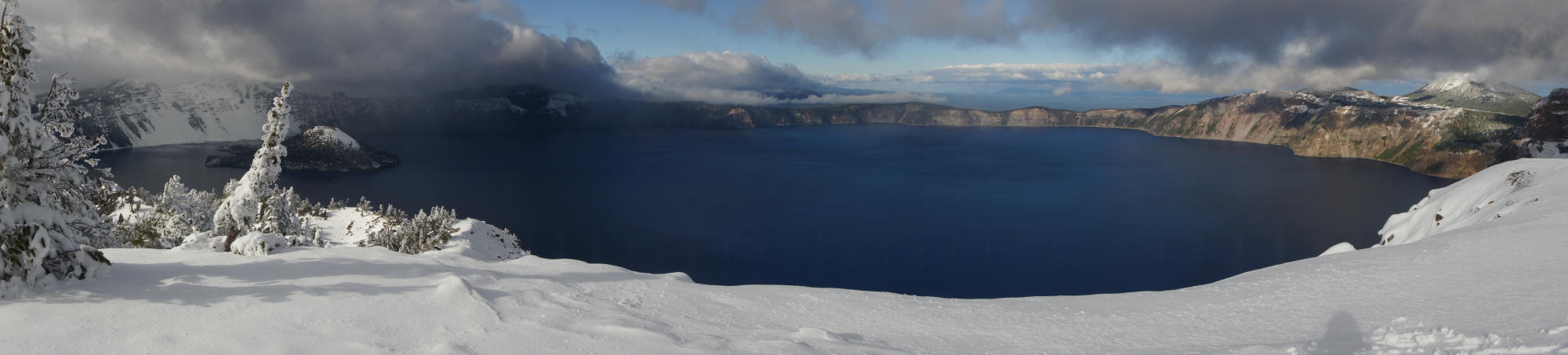
Finally, I arrived at the top. It wasn’t an easy hike, but the reward was excellent! Just look at that sweeping view from the top of Garfield Peak.

With snow everywhere and no place to sit down, this is the closest I could come to a self portrait.

At the top of Garfield Peak, there were more snow-plastered evergreens…

… and a nice view looking away from the lake, to the south.
It took me about 90 minutes to hike up to the top of Garfield Peak (with plenty of stops for pictures), and about an hour to hike back down to the trailhead. I would imagine you could hike it faster in the summer, when the trail is snow-free, but you might want to spend more time at the top.
The Bottom Line
Garfield Peak is the best trail I hiked during my visit to Crater Lake. Expect it to be more crowded than some of the other trails, mostly due to its proximity to Crater Lake Lodge and Rim Village. If the Rim Drive is closed, Garfield Peak is your best (and really, your only) option for a good hiking experience at Crater Lake.
Location
Oregon Route 62 is kept open year-round, from Klamath Falls to the south rim of Crater Lake. Unless a snowstorm has just recently hit, you should be able to get to Rim Village and Crater Lake Lodge.
Park at the lodge, or as close as you can get to it, then walk over to the rim and take a right. You’ll be on the trail, headed towards Garfield Peak. The hike is about 3.5 miles, round-trip.
Drivelapse Video
Check out this time-lapse, dash-cam video tour of the Crater Lake area:


No comments