
As Day 3 was quickly coming to an end, I was wondering if my body was acclimating to the high elevations in Colorado. I have experienced severe altitude sickness before, so I had planned this trip to allow a couple of mile-high days, before advancing to any two-mile-high areas. There was only one way to find out if I could handle a high mountain pass — I had to drive up one. Fortunately, Guanella Pass was just a short detour off my path to Silverthorne for the night.

The journey up Guanella Pass Road begins with a drive through quaint little Georgetown, Colorado. It looked like the kind of town I would enjoy — with an authentic, western downtown filled with stores and photo opportunities. It’s too bad I had arrived so late in the day. I was racing to see the pass before sunset, and I knew I didn’t have time to spare.

As it leaves Georgetown, Guanella Pass Road heads south, cutting through a valley that grows narrow and gains elevation. The road was in great shape. It appeared to be freshly-paved, so recently so, that it lacked a center stripe.

No surprise, there were a few hairpin curves on the way up from Georgetown (elevation 8,530 feet) to Guanella Pass (elevation 11,669 feet) — that’s a 3,139 foot gain, or about 6/10 of a vertical mile.

At the top, there are a couple of small rest areas and short trails that let you explore the tundra above tree line. In the photo above, you’re looking north, back towards Georgetown.

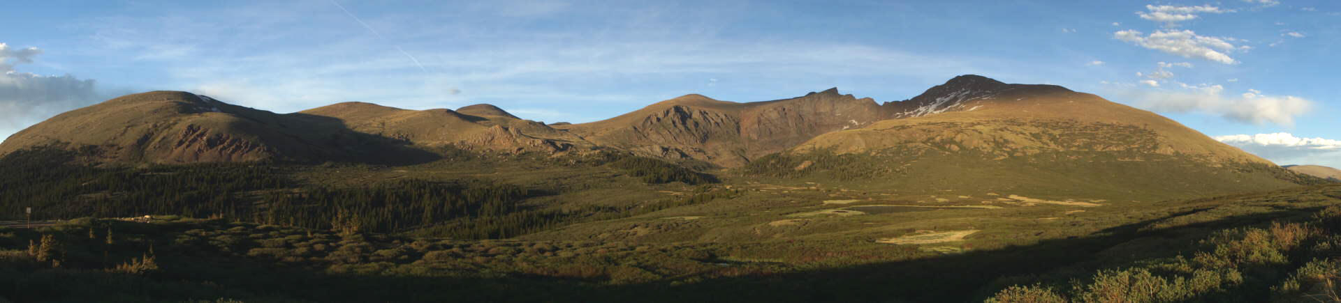
The setting sun was doing a great job illuminating the mountains to the east…

… but everything to the west was a little too bright. I think you might be looking at Square Top Mountain, elevation 13,794 feet (4,204 meters), but I’m not certain.
Click on the image for a larger version.
One thing is for sure, the view to the east, which includes Mount Bierstadt (elevation 14,060 feet, on the right), The Sawtooth (in the middle), and an assortment of other peaks, is outstanding.

From here, you can hike to the top of Mount Bierstadt. It’s considered to be a fairly easy hike, at least, for a 14’er. The summit is about 3 miles away by foot, with the biggest obstacle between here and there being the Bierstadt Willows, the marshy area you see in the foreground. I’ve read that there is now a boardwalk that crosses the Willows, which should make the journey easier.
Drivelapse Video
I drove a short distance beyond the summit of Guanella Pass, just to see what was on the south side. At this time of evening, it was already dark and shadowy over there, so I made a u-turn and headed back over the summit, then down to Georgetown and I-70. You can see it all, including a little bit of downtown Georgetown, in this time-lapse, dash-cam video of the drive:


No comments