
Gold Camp Road is a former railroad route that’s been converted into a remarkable scenic drive around the south side of Pike’s Peak, connecting Colorado Springs with the mining towns of Victor and Cripple Creek. It’s especially beautiful if you can time your visit to coincide with the fall colors — but the drive is enjoyable any time that the road is open.
My Visit
I’ve driven Gold Camp Road several times, but on this trip, I had a specific mission in mind: find some beautiful fall colors. It was October 6, 2014 — a year when the leaves were running a bit later than usual. I don’t think I was there for the peak of color, but I was close.
From Colorado Springs, you access Gold Camp Road via Old Stage Road, which climbs quickly into the hills. You’ll briefly have a nice view of Colorado Springs, and then it disappears, as you head into the forest. The leaves weren’t great at first…

… but it didn’t take long to find some aspen trees that were at the peak of color.

Reds and yellows mixed with trees that had not yet changed, making it hard to tell whether I was at the peak of color, or slightly before or after it.

You get one final glimpse at Colorado Springs at this small parking area, in the shadow of St. Peter’s Dome.

A 7/10 mile (one way) trail leads to the dome — which is that rocky outcropping on the left.

I found more beautiful trees as I continued along the road. In this area, all the trees on the right were at their peak, while all the trees on the left side of the road had lost their leaves altogether.

I’d be interested to know the history behind this old jeep. It’s obviously been abandoned here for quite a while.

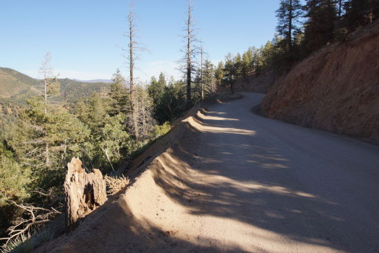
Gold Camp Road is mostly wide and easy to drive, but there are numerous spots where it reduces to one lane, as it squeezes through a narrow cut in the rock. I’m standing on one side of that cut, waving to my shadow on the other side — with the road below.

Gold Camp Road gets more interesting as you go. You won’t pass over any trestles, but there are plenty of places where a small valley has been filled with dirt. It feels like you’re crossing atop a dam, even though there’s no water on either side.

I did find some water at this small lake — which was really more of a puddle.

Plenty of color in the trees here!
Here’s another example of a spot where the trees on one side of the road had already turned and fallen, while the other side was brilliant.

You will pass through one tunnel on the drive from Colorado Springs to Victor. It’s only a little scary.
A sign near the entrance to the tunnel explains the history of Gold Camp Road. It explains how the road was originally a trail used by the Ute Indians, then as a railroad to haul gold ore from Victor and Cripple Creek to the mills near Colorado Springs. The railroad operated from 1901 to 1920.
In 1926, coal mine owner W.D. Corley bought the defunct railroad, removed the tracks, and added toll booths — creating a toll road known as the Corley Mountain Highway. His permit expired in 1939, and the road was turned over to the forest service. Tunnel #9 was restored, allowing the road to be open, and free, for tourists and locals.

Some of the most interesting geology is found on the west side of the tunnel. There are several spots, like this one, where the landscape opens up to reveal some interestingly jumbled mountain peaks.

In this spot, it’s still unclear whether I had missed the peak of color by a few days, or if those green trees were still turning.

The road makes a wide swing across another dirt bridge…

… providing a great view of the valley below.

This spot looked somewhat different in 2005, nine years earlier, when I stopped here.

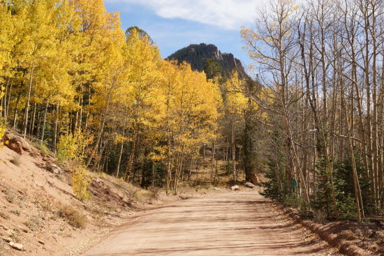
After those dramatic scenes, Gold Camp Road opens up to reveal a wide valley with rolling hills to the west. There were plenty of aspen leaves to see in this area, which is known as Beaver Valley.

When you reach the end of Gold Camp Road, turn left and drive down to Victor. This is one of my favorite Colorado small towns. It’s loaded with old, semi-abandoned buildings and streets, ghost signs, and relics from the mining boom days. On this trip, I didn’t have time to stick around and explore — I needed to make it all the way to Aspen that night. So, you can check out my previous visits to Victor here.
You also may want to drive up to the American Eagles Mine Overlook, for a view of the modern-day operation that’s left a big impact on the land around Victor.
The Bottom Line
Gold Camp Road is a fun drive through some beautiful scenery, during any time of the year when it’s not closed by snow. It’s even better during fall, most likely around the last week of September or first week of October, when the leaves reach their peak color.
Location
Gold Camp Road’s eastern end, near Colorado Springs, is permanently blocked by a tunnel collapse. To access the road, you’ll need to start on Old Stage Road, near the entrance to Cheyenne Mountain Zoo. You probably won’t notice the spot where Old Stage Road becomes Gold Camp Road — just keep following the main road and you can’t get lost, all the way to Victor, Colorado.
If you’re coming from Victor, take Country Road 81 north (like you’re headed to the American Eagles Mine overlook). Gold Camp Road will turn off to the right, about 4 miles north of town. The road is marked with a Country Route 8 sign, and a brown Forest Service sign that points to Colorado Springs.
Drivelapse Video


Thank you for such an elaborate story! Exactly what we were looking for- usually we take 24 to reach Victor- this was some surprise!