
New Mexico Route 152 is a very curvy, mostly 2-lane road that connects the town of Silver City with Interstate 25. It makes up a portion of the Geronimo Trail National Scenic Byway (which also includes parts of New Mexico 52, 59, 181, and 187, to the north and east). Route 152 passes by some impressive mountain scenery, as well as a couple of small towns, and one of the world’s largest open-pit mines.
My Visit
Leaving I-25 behind, New Mexico 152 starts out uneventful, but before long you’re headed towards the mountains, and the road grows more interesting. At first, you reach some rolling foothills, and eventually, you’re climbing some sizeable mountains.

At the foot of the hills, you’ll want to stop and walk around for a few minutes in the appropriately named town of Hillsboro. An old motel has some nice neon…

… and a bit further, you’ll arrive in ‘downtown’ Hillsboro. It’s a short stretch of old buildings…

… with a tiny business district.

HIllsboro is big enough to have its own post office…

… and the historic Our Lady of Guadalupe Catholic Church.

I also spotted this mural on a wall in Hillsboro.
Just a short distance beyond HIllsboro, you’ll pass by the only other town on this part of the drive, Kingston. It’s located off the main road, and I didn’t take the side road to check it out.

Beyond the towns, as you plunge into the tight curves of the Black Mountain Range, you’ll come across the Percha Creek Bridge over a steep-walled canyon. The old, original bridge, built in 1927, is a Warren Deck Truss bridge that made the Black Range Highway possible.

The road now crosses the canyon on a newer, more modern bridge, but you’re free to walk across the old structure, if you need to stretch your legs. The old bridge dead-ends at the far side, so there isn’t much else to see here.

Speaking of bridges, NM 152 crosses a couple more steel bridges, further up the road. These are single-lane bridges, so keep an eye out for oncoming traffic.

As you approach Emory Pass, you’ll find several opportunities to pull off the road and admire the view. In most places, you’ll be able to see the road you just traveled, cut into the side of the hills.

The best views are at Emory Pass itself. Here at 8,166 feet, you’ll find a parking area, allowing you to safely stop and enjoy the view.
Looking down the valley (just left of center in this photo), you’ll be able to get another look at the town of Kingston, which was a boomtown of 7,000 people, back in the late 1880’s. On a clear day, you may be able to get a glimpse of Hillsboro and Caballo Lake in the far distance.
Click on the image for a larger version.
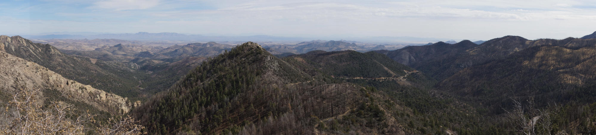
A wider view reveals even more of this landscape. You can see Highway 152 cut into the mountainside, in the middle of this photo. On the far right, you may be able to see Seven Brothers Mountain.
You’ll also see a whole lot of burned trees. Wildfires ravaged this area, just a few years before my visit. It may be decades before you’ll find a thick forest here again.

After the road’s high point, you’ll drop down through a scenic, rocky canyon.

Just a few minutes outside Silver City, as the scenic highway nears its end, there’s a sight that’s interesting to see, but certainly not scenic:

This is the Santa Rita, or “Chino” open-pit mine. They’ve been digging into the earth and removing copper here since 1910. At one point, it was the largest pit in the world, but it has since been surpassed by a mine in Chile.
You’ll find a fenced-in viewing area at the side of the road, complete with picnic tables.

An old tire from the huge mining equipment is on display at the overlook. It’s partially buried in cement, and probably about 8 feet tall. There’s a big sign on it, ordering you not to play on it. I hadn’t even thought about climbing on it until I read the sign, but once I did, that’s all I wanted to do.

I guess it would be okay to climb inside it.
After the mine overlook, it’s just a short drive on into Silver City, New Mexico, which I’ll cover on a separate page.
The Bottom Line
If you’re traveling into this corner of New Mexico, you’re obviously up for some adventure and solitude. New Mexico Highway 152 is a great way to plunge deep into the Black Mountains. Keep in mind that your cell phone coverage will be limited, and passengers in the car may want to pop a Dramamine — this is a very curvy, and somewhat tiring road, but it does reward the effort with plenty of beauty.
Location
This drive on New Mexico 152 begins at Interstate 25, exit 63, near Caballo Lake State Park. The road heads west, across flat terrain at first, and then the curves begin. NM 152 passes through Hillsboro and skirts the edge of tiny Kingston, then climbs to Emory Pass, where beautiful views of the mountains await. After gaining elevation, the terrain levels out somewhat, as the road heads towards Silver City. NM 152 ends at Santa Clara and US 180, approximately 15 miles outside of Silver City.
Drivelapse Video
Check out this time-lapse, dash-cam video of the drive through Kingston and Hillsboro…
… and then on to Emory Pass and Silver City:


No comments