
If you want to see Autumn colors like this, you need to go to Vermont in October, right? Actually, no, you don’t. Much to my surprise, I found these beautiful red, orange, pink, and yellow leaves in New Mexico, of all places. Of course, they’re not everywhere. You will have to seek them out. And the best fall colors are virtually hidden, tucked away on the eastern side of the Manzano Mountains, in the Cibola National Forest southeast of Albuquerque.

You can access several great trails, by parking at the Fourth Of July Campground trailhead. As I’ll explain, I’m not exactly sure which trails I hiked, but no matter where you end up, you can’t go wrong if you’re hiking here in early October.
I should also mention that on this hike, my good DSLR camera, a trusty old Sony Alpha 100 that I had used for 5 years and 50,000 exposures, suddenly died on me, just as I was starting the hike. So, I was forced to take photos of all those beautiful fall leaves using my cheap Drivelapse video camera. It did okay, but I would have taken much better pictures if I had the good camera.
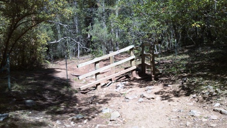
The Fourth of July Trail leaves from the upper end of the campground area. You’ll need to park at the picnic area and walk through the camping area to find the trail. The path passes through a couple of gates, like this one, as it heads slightly uphill.

The Fourth of July Trail runs along the bottom, or near the bottom, of a shallow valley. Thanks to the constant drainage…

… from the Upper Fourth of July Spring, everything stays lush and green during the summer, and that moisture allows the right kind of trees to grow here (like maples), to produce fall colors.
It was around this area that somehow I took a wrong turn. My plan was to follow the path laid out in my guidebook, 100 Hikes in New Mexico. It suggested I hike up the Fourth of July Trail, then turn right onto the Albuquerque Trail, looping around via Canon de la Gallina, eventually returning to the road, then back to the parking area.

The only problem is, this sign was missing an arrow. It should say that the Albuquerque Trial turns right, but without that chunk of wood, it looks like it goes straight. Turning right didn’t make sense anyhow, since a right turn appeared to put be back on the Fourth of July Trail, which is what I came in on. So, I decided to go straight, and continue on the Fourth of July Trail (Number 173) towards Cerro Blanco Trail (Number 79).
I’m not willing to say that I went the wrong way. I’m quite certain that the route I hiked was better than the one I intended to hike.

Continuing uphill, I passed by spots where a thick layer of pink leaves had covered the ground. It seemed that pink was the most prominent color on this hike — not bright red.

There was plenty of yellow, as well. At this point, the trail was headed uphill, rather quickly.

On through the woods, at some point, I ended up on the Cerro Blanco Trail…

… which led to the Crest Trail. I passed a group of hikers, who strongly recommended I hike on up to the top of the hill. Since I had no idea where I was, I figured, why not?

As the Crest Trail headed uphill, the trail was slightly overgrown. I had to push my way through shrubs in places. I also noticed that those shrubs were actually trees, that were stunted — probably due to strong winds sweeping over the ridge.

The slope was covered with fall colors. After huffing and puffing my way up the trail…

… I made it to the top, where I finally had the chance to figure out exactly where I was. To the north, this pair of perky hills consists of Guadalupe Peak (on the left, at 9,450 feet/2,880 meters) and Mosca Peak (on the right, at 9,509 feet/2,898 meters). This saddle is probably somewhere around 8,700 feet above sea level.
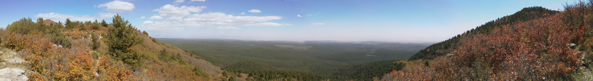
Click on the image for a larger version.
Facing east, I was looking back towards the direction of the parking area and trailhead. This side of New Mexico looks lush and green for miles — a big difference from…
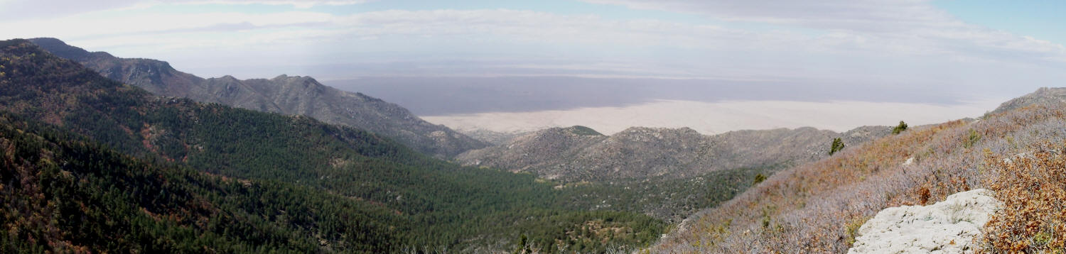
Click on the image for a larger version.
… the view to the west, where the nearby peaks appear dry and barren, and beyond them, the desert stretches out endlessly.
It was so windy on the ridge, that I didn’t spend much time up there. All the plant life had been reduced to foot-tall brush, so there was no protection from the wind that howled up the western slope.
This was, however, the only place on the entire hike that I had cell phone coverage, so I took a moment to call a friend and asked her to look up the error code that my camera was producing. The first result she found said something like, “Hey Sony, thanks for my new paperweight!”. I begrudgingly gave up on the hope that I could do something to quickly fix my camera.

Once off the ridge, I decided to hike a bit further on the Crest Trail, headed north. I thought that there might be a chance that it would loop around and end up back at the trailhead (I was wrong — it does not). But, the extra walk along the Crest Trail did take me through more impressive patches of fall colors.

The trail took me around a smaller hill, and back to the top of the ridge…

… at the southern foot of Mosca Peak.

Once again, I had a nice view of the desert to the west.
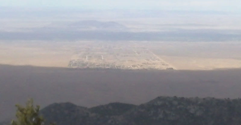
Click on the image for a larger version.
From here, I was looking directly down onto the community of Meadow Lake. It’s a strange place, where there are, apparently, no meadows and no lakes — just a network of dirt roads, scratched into the desert dirt, connecting to some mobile homes.
Since I still didn’t know exactly where I was, or whether the trail I was on would take me where I wanted to go, I decided to turn back, and simply enjoy the colors as I backtracked.

There were plenty of oranges…

… and a few patches of red (almost purple!)…

… and yellows covering the ground, providing a nice “swoosh swoosh” sound as I walked.

Back at the Upper Fourth of July Spring, I decided to follow the “low road” — an alternate trail that stays closer to the trickle of water produced by the spring, as it flows down to the campground.

The trail crosses over the creek a few times, which means some spots are muddy, but there were also plenty of nice, colorful trees to photograph.
So, how far did I hike? I have no idea. I think I hiked for about 3 hours, but I’m not sure my cheap-o camera correctly time-stamped my pictures.
Location
The Fourth of July Campground Trailhead is located near Tajique, New Mexico. From Albuquerque, take I-40 east to exit 175, then NM-337 south, through Chilili, to the dead-end at NM-55. Turn right, and head to Tajique. In town, NM-55 will go around a curve and up a small hill, headed towards a water tank. As you go up that hill, watch for a dirt road on the right. This is Forest Road 55, and if you’re lucky, there will be a sign for the 4th of July Campground. Follow the dirt road to the parking area, approximately 7.5 miles. The dirt road is easily passable in any car, but it turns more primitive beyond Fourth of July.


No comments