
Chiricahua National Monument has a ‘back door’ of sorts. You can reach the park from the east, by driving over some rough dirt roads. In the process, you’ll experience some wild backcountry in this far-flung corner of Arizona.
Admittedly, the story on this page is a very personal one. If you can put up with all of my reminiscing, you’ll find some good information mixed in.
My Visit
I can’t tell the story about this trip over the Chiricahua Mountains, without telling the story of my first trip over this route. It was 1985, and I was a 10-year-old…
… romping around seatbelt-free on a foam mattress in the back of our Dodge station wagon. Every summer we took a big road trip, but this was the biggest one ever. We left our home in West Virginia and, for the first time, headed west.
I had grown up around hills, but had never seen mountains. The concept of climbing thousands of feet, while clinging to the edge of a slope on a shelf barely wide enough for the tires was enough to leave me speechless and slightly terrified.
My father, a devout West Virginian, had lived out west for just a few years of his life, but it was enough to convince himself that he was an expert on it. He had a few friends from his previous life, before he had married my mom and settled into our modest brick house. One of those friends lived in Douglas, Arizona, on the border with Mexico, and that’s where we were headed on this particular leg of our road trip. I guess our plan was to bypass Chiricahua altogether, as we made our marathon-like sprint across the country, attempting to see as much and as little as possible, all at the same time.
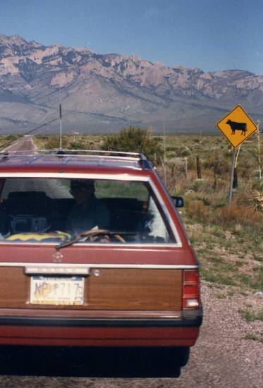
So there we were, traveling down historic Route 80 towards Douglas, when my dad gazed over at those mountains, and realized we were missing something important. Given his western expertise (or maybe just the entry in the AAA guidebook), he knew that Chiricahua was a “Wonderland of Rocks”. So when he saw a side-road that headed directly toward those mountains, he decided to take it.

As far as I know, there was no sign saying the road would take us to Chiricahua. It was just an intersection with a cattle-guard, in the middle of nowhere. But there we were, without a GPS device or cell phone, in a worn-out car that had been driven way too much in the past few days, headed towards some incredibly lonely mountains. And so began the most defining adventure of any of our crazy family road-trips.
29 years later, I was on my way to visit Chiricahua, but I planned to use the front door — to spend the night in Willcox, Arizona, and then drive down Route 186 to the park’s main entrance. I knew Willcox was a boring little town, and I was on track to get to my one-star motel by late afternoon. I wasn’t thrilled with the thought of a long evening with nothing to do.
As I headed west on I-10, I knew I was coming up on the Route 80 exit. I thought back nearly three decades, and decided it was time to make another spontaneous decision. Would I be able to find that same road that took us over the mountains? Would I recognize that lonely intersection in the middle of nowhere? I had to try.
I’ll never know for sure, but I think this is it:

This is New Mexico 533, one of the shortest roads in the New Mexico state highway system. It’s much more developed now, than it was in 1985. Nowadays, the only thing you’d recognize, besides the mountains, is the cattle crossing sign. The road is nicely paved, with a stripe down the middle, and a few homes and barns stand in the distance.
Where 80 meets 533, there’s a sign pointing to the community of Portal and Chiricahua National Monument. Across the street, there’s the Chiricahua Desert Museum, which is filled with live snakes and other desert creatures, and some Native American artifacts. None of this was around, back in ’85.
So, I set out on the very short Route 533. In less than a mile, the road crosses into Arizona…

… with no fanfare, other than an intersection with “State Line Road”. This is where I first entered Arizona as a kid, although at the time, this important event went unnoticed.

The community of Portal is just inside Arizona, just before the pavement runs out. Here, you’ll find the Portal Store, Cafe, and Lodge.

Judging by the front door on the place…

… and the car parked out front, this store has been here for quite some time. Presumably, it was here in 1985, but for some reason we didn’t stop here to ask for directions.
The Portal area, and neighboring Cave Creek Canyon, is very popular with bird-watchers. Nearly half the species of birds in North America can be spotted here.
At the western edge of Portal, the road splits. Take a right, and you’re headed to the ghost town of Paradise, and eventually, Onion Saddle and the rest of Chiricahua National Monument. The road to the left looks much more interesting — it heads into Cave Creek Canyon.

I figured I had enough time to do a little exploring before heading over the mountains, so I went left at the fork, and drove a short distance into Cave Creek Canyon. Even though the sky was overcast, it was still an impressive sight. The canyon is often called the Yosemite of Arizona, and while it’s not quite as overwhelmingly grand as the original, I can see the similarities.
I’m not sure how far you can take this road, but I do know that there are several campgrounds along the way. I found a turnout and parking area, marked with the sign, “Vista Point”, and decided to check it out.

A short hiking trail leads up to Cathedral Vista, where the towering mountains surround you.

I’m guessing the caves and crevasses in those rocks are great places for birds. My visit was in late February, a couple of months before many of the migrating birds arrive from Mexico.

The viewpoint’s centerpiece is this rocky peak. I would have loved to have seen it at sunset or sunrise, on a more beautiful day.
If I had driven further, I’m pretty sure I could have connected with roads that would have eventually taken me to the same place I was going. At the time, though, I didn’t know that, so I backtracked to Portal, and took a right at the fork.
I thought back to the first time I had ventured over this road. Of course, I don’t remember many of the details, since I was in the back-seat and not really paying attention to left and right turns. I do remember, however, some steep drops and impressive views on the passenger side of the car.

This time, as I made my way into the mountainous wilderness, I was beginning to wonder if I was on the right path. The road was staying low, and I was passing a lot of mailboxes and homes. None of it seemed to match what I remembered. Was I in the wrong place entirely? Had my imagination changed my memories?

I kept heading in the most logical direction, fording one small creek, and making several turns. My GPS helped, but I still wasn’t convinced that I was on the right path.

Signs seemed to indicate that I was headed towards Paradise, and I knew that was a good thing. There isn’t much left of this ghost town today, but I seemed to remember us passing by it, or near it, when I was a kid.

Finally, a promising sign. “Narrow Mountain Road, Next 13 Miles”. A narrow mountain road was exactly what I was looking for. Suddenly I was hopeful again. I must be on the right path.

Indeed, the road did start to climb, and I was soon treated with views of the surrounding mountains.

Also encouraging, the drop-off was now on the right side of the road, just like I remembered.
The only thing that still didn’t match up, was the trees. Back in 2011, a massive wildfire swept through this area. The Horseshoe 2 fire ended up scorching 348 square miles, making it the 5th largest wildfire in Arizona history.
That fire seriously altered the scenes I remembered. Instead of brief views, interrupted by a dense forest, I was now seeing almost unlimited views, with a few tree-skeletons in the way.
Back in 1985…

… without a clue of where we actually were…

… our drive skirted the edge of a much more densely-forested mountain, and eventually reached its high point. A wooden forest sign welcomed us to Onion Saddle, elevation 7,600 feet.

It was probably the highest elevation I’d ever experienced. The truth is, though, there wasn’t much there to see. We got out, walked around for a few minutes, then got back in the car.
But it didn’t start.

This kind of thing was a much bigger deal in 1985 than it is today. We couldn’t call for help on a cell phone. And without GPS, we really didn’t know exactly where we were. Onion Saddle wasn’t important enough to be marked on any map.
My dad popped the hood, and stared at the engine. He was never a ‘car guy’, and I’m pretty sure he didn’t have a clue what to do. My mom worried. It’s one of the things she did best. We started thinking that we were going to be spending the night at Onion Saddle.
I wish there was a more dramatic twist to this story — maybe something MacGyver-esque, that somehow fixed our engine trouble. But the boring truth is, eventually, the car simply started. I don’t think my dad actually did anything. He later surmised that it was “vapor lock”, a problem that apparently happened to cars during a dramatic change in elevation, back in the day. The mysterious ‘vapors’ eventually disappeared, and the station wagon was rolling again.

29 years after that day, I wandered around that same intersection, trying to picture it with un-scorched trees. I looked around for the old Onion Saddle sign, but it was long gone.

Even if that old sign had still been here in 2011, it would have been destroyed by the wildfire. Instead, a new sign has taken its place, complete with a misspelling of “Willcox”.

Try as hard as I could, there was no way to picture this spot in the same way. The forest fire hadn’t helped. Neither did the fact that I knew exactly where I was. Oh, and also, I wasn’t 10 years old this time. The mystery was gone.
The only suspense remaining was whether my car would start. Vapor lock doesn’t happen very much these days. The biggest risk was that I could misplace my keys. And believe me, I was very careful to keep track of them.

So, for the second time in my life, I headed down this road. Once you cross the cattle guard, you’re entering Pinery Canyon. This road drops down to Chiricahua’s main entrance, passing a large campground along the way. I remember us stopping at that campground, and finding someone to ask for directions. It was the first of many opportunities for my father to tell the tale of getting lost, and nearly stranded, in the Chiricahua Mountains.
Once back on the pavement, in 1985, we drove out to Massai Point…

… for some pictures with dead trees. That’s one of the other things that my mother did best.
Then we headed south to Douglas, met my father’s friends, and settled in for the night. In 2014, I drove on to Willcox, and checked into my boring motel. The two vacations that briefly paralleled, separated only by time, diverged. But at least, for a little while, I was a little closer to being a 10 year old in the back of a station wagon again.
The Bottom Line
I don’t necessarily recommend you take the dirt-road drive over the Chiricahua Mountains, unless you need to get from one side to the other, and you don’t want to take the long way around. I do recommend you check out Cave Creek Canyon, and I strongly suggest you spend a day in the more developed areas of Chiricahua National Monument. Consider hiking the Big Loop, if you’re up to it. However, the drive over Onion Saddle is marred by the recent wildfires, and would probably not be as satisfying to anyone else, as it was to me.
Location
Chiricahua’s back-door route begins in New Mexico, along Route 80 (formerly US 80). At the Chiricahua Desert Museum, turn west and drive through the community of Portal, then keep going. There are a couple of routes you can take — the route I followed crossed Onion Saddle, then descended Pinery Canyon Road to the park’s main entrance. I’d strongly suggest using a GPS device to help with selecting the correct route.
Drivelapse Video
Check out this time-lapse, dash-cam video of the drive over the Chiricahua Mountains:


Cool post; thanks for sharing! It appears you made the drive(s) in a standard 2WD car, correct? A high-clearance 4WD is not required for this route? Thanks
I made it okay in a standard rental car. That was a few years ago, and it’s hard to say if the road conditions are the same now. But, it was no problem when I did it.
Great story as I am sitting here in the Phoenix planning my visit to the National Monument in 2 days. I was thing on drying from Wilcox both ways in my own sedan but won’t do that.
Now I know why google maps lists the 1 way drive from the National Monument to Portal (24 miles) as 1 hr 23 minutes.
Wonderful story , thank you for sharing. Those mountains are beautiful. Childhood memories are the best!! I live in area and i need to visit them more!!