
The secret to a good road trip? Take a chance on a road, just because it looks interesting on a map. That’s what I did at Dotsero, Colorado — a nearly non-existent speck on the map, a lone exit off of Interstate 70, at the eastern end of Glenwood Canyon. I could have remained on the freeway and enjoyed a nice, fast drive through Colorado to my stopping point in Silverthorne. But I didn’t. And I ended up seeing an amazing place, that as far as I can tell, almost no one knows exists.

Colorado River Road follows… you guessed it… the Colorado River, from Dotsero to another one-horse community known as McCoy. In between, there’s even more of nothing, in the way of civilization. There is, however, an amazing journey here.
Why Colorado River Road isn’t designated as a scenic byway, I’ll never know. Maybe it’s because it’s not paved the whole way through — although the lack of a sealed surface presented no challenge.
So, let’s begin. From Dotsero, I turned onto the Colorado River Road. It heads north, then northeast…

… following the Colorado River through an endless canyon of dramatically eroded cliffs. Visit in a few million years from now, and perhaps you’ll be in the middle of a canyon even more grand than the Grand Canyon.

There are plenty of pull-offs in key places — a sign that someone has figured out that this is a road meant for stopping and picture-taking.
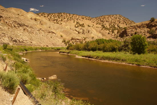
At times the road is high above the river, in other places, you’re driving alongside the water.

There’s my rental car, looking as if it’s the star of a Mazda commercial.

At one point, the road climbs a hill. As it tops out, you’ll have a great view of the valley below. Also, notice the railroad tracks, cutting through the middle of this scene. Thank goodness they didn’t make the road as straight and boring as the rails.

One scene after another unfolds, around almost every curve.

Yes, that really is a 2-headed donkey.

At one point, about a third of the way to McCoy, the road makes a sweeping curve, following the river as it passes around a hill.

There are a few farms and homes in this area, but don’t expect a gas station or convenience store.

The Colorado River Road turns to dirt for just a few miles, and travels directly alongside the railroad tracks.

Even though the road is dirt, you won’t have any trouble traveling at the speed limit — whatever it may be. The road is well-maintained, smooth, and wide.

One sign of civilization: this old Conoco gas station sign. There is no gas station here — just the sign, which looks like it dates back 50 years or more.

I also found this sign lying on the ground. I don’t know where all the private homes are — although there were a few buildings across the street (that looked like an old motel, maybe), a phone booth, and maybea lived-in shack of some sort.
Surprisingly, in this area, there is a tiny post office. It’s probably the only way you’ll know you’re passing through Burns, Colorado. There’s also a turn-off for Derby Mesa Loop, which would take you up to the top of the nearby hills, then back down to Colorado River Road. I didn’t take it, but it might be a worthwhile detour.

Shortly after Burns, the dirt road gains some elevation…

… and leaves the river behind for a short while, as it passes through a wide valley.

It’s here that I found one of the most interesting places along this road. It’s an old corral of some sort, with fences and structures that are slowly collapsing.

It feels like this area has remained untouched for decades — at least since the time when beer cans had pull tabs.

I’m guessing this was more than just a corral. It looks like it had a few rows of bleachers. Maybe it was an auction site for livestock? Or some kind of rodeo?

Whatever it was, there were plenty of excellent photo opportunities here, all unrestricted by fences.

And once again, the road itself was simply incredible.

I spent the final few miles of Colorado River Road racing with a train, that was on the tracks next to the road. If you watch the Drivelapse video, you’ll see me trying my best to keep in synch with the train.
Drivelapse Video
Here’s the time-lapse, dash-cam video of the drive from I-70 at Dotsero to McCoy, via the Colorado River Road:


Really neat. Especially the almost surreal train footage.
Just discovered this…..great video!!! Thanks for sharing!! Can you tell us what Dashcam you were using. Thanks!