
The hike to Scenic Point is probably one of your best options in the Two Medicine area of Glacier National Park. It will exhaust you — it gains 2,200 feet or more in a little over 3 miles, one way. All the effort is worthwhile when you reach the spectacular view of the Two Medicine valley. If you’re in the mood for a shorter hike, you can choose Appistoki Falls as your destination, but it’s not nearly as spectacular as you might hope.
My Visit
It’s a good thing that, in late June, just as summer is beginning, the days are ridiculously long at Glacier National Park. I was hiking this trail on the first day of summer, giving me the latest sunset I could ever hope for. Even with that extra daylight, I could have used, perhaps, an extra 15 minutes in the day, and an extra burst of energy, to make it all the way to the official Scenic Point. But, I made it far enough to give you a very good impression of this trail. Here’s a short list of what to expect: shortness of breath, weak legs, total exhaustion, and a view that just won’t quit.

Let’s start at the beginning. I set out on the trail at 5:49 p.m., after a day of driving around to Glacier’s east side, then taking the boat tour of Two Medicine Lake, and hiking to Twin Falls. It had already been a long day, and I figured I’d probably go as far as Appistoki Falls, maybe a bit further, then turn around and call it a day. I’m pretty good at lying to myself in situations like this. After all, how could I leave a destination known as “Scenic Point” unvisited?

The first part of the hike is somewhat unremarkable. It was uphill, but not terrible, with beautiful mountains peeking through the trees.

In about a half-mile, there’s a turnoff for Appistoki Falls. The view of the falls is just a short distance down this side-trail…

… which ends with a less-formal sign.

Appistoki Falls is a decent-sized cascade, but it’s partially hidden by the deep groove it has cut into the rock. If you could hop over to the other side, you could get a nice picture, but that’s not possible.

This also isn’t the perfect time of day to visit Appistoki Falls (or for that matter, the entire trail up to Scenic Point). With the sun hanging low in the sky, the canyon is dark.

Then again, maybe the canyon is always dark, judging by the big chunk of snow that still hadn’t melted as of the first day of summer.
Returning to the main trail…

… the landscape begins to change, and I started to get an idea of where I was ultimately heading. The trees were thinning out and looking stunted, and the scenery further ahead looked almost post-apocalyptic.

The main trail swings around to the top of Appistoki Falls. For the next little while, the trail climbs out of the Appistoki Creek valley.

Ahead is Mount Henry, the trail’s namesake. You’ll be climbing for the next hour or more. Late in the afternoon, it’s beautifully lit…

… while the mountain on the right side of this picture, Appistoki Peak, looks dark and shadowy.
After you leave the creek behind, the trail skirts the side of the mountain, climbing steadily. It’s in this area that you’re above the tree line — or at least, above the living trees. There’s a vast forest of bleached tree skeletons here.

Some of the mighty trunks have fallen…

… but most are still standing. I swear, this picture is level, but the steep slope of the mountain, and the crooked trajectory of the trees, was messing with my perception of “up”.
The trees are fun to photograph, but at this point it was 6:38 p.m., and I began to realize that I had already hiked farther than my original goal. So, I started doing the math. 50 minutes to this point would be about 40 minutes on the return trip. I could easily hike another mile or two before turning around, and still have enough time to get off the trail before dark, right?
I decided to go as far as I could, all while estimating my remaining hiking time, in order to calculate the ultimate, no-if’s-and’s-or-but’s turn-around time.

A bit further up, I turned around and took this picture of the view downhill. Shadowy Appistoki Peak is on the left, with Appistoki Creek in the valley below. Directly ahead is Rising Wolf Mountain, on the opposite side of Two Medicine Lake. If you’re hiking here in the afternoon or evening, you’ll never have a great view of Rising Wolf, because the sun will be in your eyes.

The skeleton trees were now gone, and the rocky trail reached some switchbacks. The climb was taking me higher up the hill, and that added altitude was allowing me to see a little sliver of Two Medicine Lake. The higher I went, the more would be revealed.

The view ahead looked a lot like this for a while. Up on the left, there was an obvious saddle between two higher points. Descending hikers told me the trail crested at a saddle, but it wasn’t the one you could see from here. The actual saddle was further to the left.

After another patch of tree skeletons…

… the trail entered a starkly barren patch, then switched back…

… towards more trees, and a surprising patch of tiny wildflowers. It’s amazing what manages to live at this harsh altitude, clinging to rocky soil.

My next pass through a patch of trees included a patch of snow. This kind of snow — the last remnants of frozen slush — is always hard to walk through.

The best view was just ahead at the final switchback. At this point, you can see the entire Two Medicine valley, unobstructed by anything. It would be a fantastic sight in the morning — but as evening approached, the sun was casting some heavy shadows. I checked my watch. 7:35. An hour and 45 minutes to get to this point.

Admittedly, at this point, I was walking very slowly. It took another 8 minutes to get to this point, and I reluctantly accepted that I could go no further. It took me nearly two hours to get here, so I knew the hike back would probably take up to an hour and a half. The valley was already getting dark. And the truth was, I was too exhausted to make the final push up to the saddle. It was just a few minutes away, but I was out of time.
So, at 7:45, I turned around.
Click image for a larger version
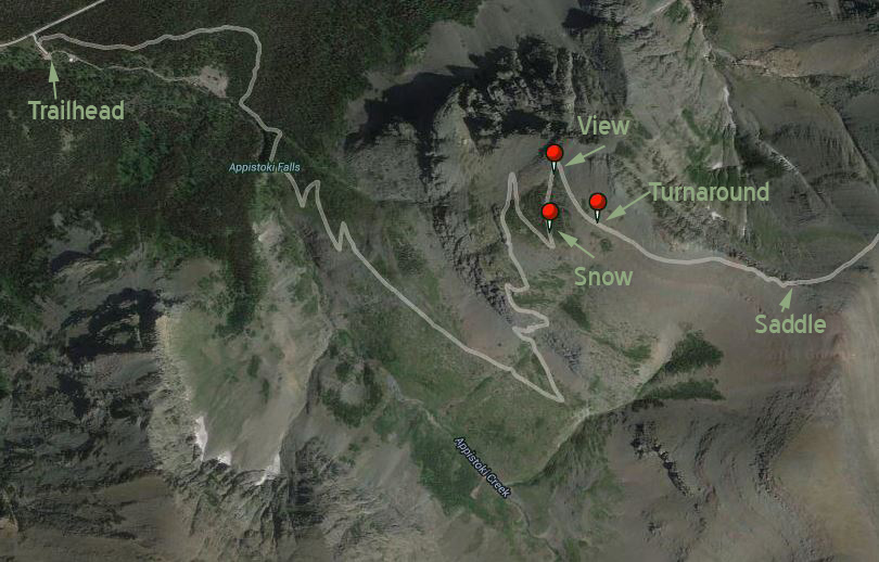
How far did I actually get? This Google satellite image shows the GPS location of the last 3 pictures above. I think, with another 15 minutes, I could have made it to the saddle, especially since the worst of the uphill climb was behind me. I can only imagine how beautiful the view on the other side of the saddle would have been.
After a very brief break, I headed downhill.

The return trip included a few minutes spent at the skeleton trees. It’s difficult to capture a photo that properly expresses their haunting nature, their timeless beauty.

A human sculptor couldn’t rival a creation like this.

At 8:23, the sun set behind Rising Wolf Mountain. At 8:59, I reached my car. It was dusk, but not dark at the bottom of the valley. Maybe I should have spent a few more minutes, and pushed my way on to the top.
The Bottom Line
Appistoki Falls really isn’t a rewarding destination. If you resolve to see the falls, and then hike on up to the clearing above the falls, you’ll get more satisfaction for your efforts. The best plan is to clear your schedule for half a day, pack a snack and plenty of water, and hike the entire trail up to Scenic Point. Even if you don’t make it all the way, there’s plenty of scenery to keep you happy.
Location
The Two Medicine area of Glacier National Park is located on the east side of the park. From US 2 at East Glacier Park Village, take MT 49 north, and watch for the Two Medicine turnoff.
The trailhead for the Mount Henry Trail to Scenic Point and Appistoki Falls is located shortly BEFORE you reach the ranger station and Two Medicine Lake (the end of the road). The parking area will be on the south side of the road.
Drivelapse Video
Check out this time-lapse, dash-cam video of the drive from East Glacier Park Village into Two Medicine, via Montana 49:


No comments